
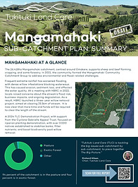
MANGAMAHAKI
CATCHMENT
Primary Township Omakere
Area 26,418ha
Land Use: 94 percent of the catchment in the pasture and four percent is in exotic forest.
CATCHMENT
GROUP
Catchment Committee Aaron Vowles, Callum Sutherland, Sarah Kingston, James Aitken, Grant Angus, Stuart McDougal
Catchment Co-ordinator Pixie Seligman
Email tukicoordinator@gmail.com
Phone 0277212423

ABOUT OUR CATCHMENT

Frequent extreme rainfall has worsened flooding, with dense willow infestations blocking waterways. This has caused erosion, sediment loss, and affected the water quality. At a meeting with HBRC in 2022, locals raised concerns about the stream’s flood risk, business impacts, and ongoing degradation. As a result, HBRC launched a three-year willow removal project, aimed at clearing 25.5km of stream. It is now clear that more time and funds will be required to clear the stream.
A 2024 TLC Demonstration Project, with support from the Cyclone Gabrielle Appeal Trust, focused on riparian planting, with over 3,000 natives established to stabilise banks, filter nutrients, and boost biodiversity post willow removal.
TLC DEMONSTRATION PROJECT - BEST PRACTICE RIPARIAN PLANTING
The ambitious project saw 3300 plants and trees planted along a stretch of the Mangamahaki Stream adjacent to the Omakere Hall.

THE BIG PICTURE
The Big Picture
As part of The Big Picture project, TLC has developed independent, science-backed catchment plans for each of the 17 sub-catchments of the Tukituki River. These farmer-led plans address key environmental challenges specific to each area while identifying practical, affordable solutions. These plans do not impose rules or regulations but they give farmers and catchment groups a roadmap for future planning to improve water quality, boost farm productivity, and open the door to future funding opportunities.
TLC partnered with environmental planning consultancy Environment, Innovation and Strategy Ltd (EIS), who collected data specific to each sub-catchment, including erosion maps, flow path models, land use capability, soil types, and water monitoring information. Alongside the scientific data, in December 2024, TLC hosted workshops for farmers and growers in each sub-catchment to make sure the solutions aligned with the realities of farming and growing in each sub-catchment.
Mangamahaki Draft Sub-Catchment Plan: Summary
Mangamahaki Draft Sub-Catchment Plan: Full Report

Mangamahaki Catchment Maps

TLC FARMER TOOLBOX
Tools for the Mangamahaki Catchment
As part of The Big Picture, TLC has developed the TLC Farmer Toolbox, designed to support landowners in making informed decisions and enable them to implement changes with confidence, ensuring that time and money are invested wisely.
The TLC Toolbox includes the following:
-
TLC’s On-Farm Action Planning Tool - prioritise on-farm environmental actions based on their cost-effectiveness and impact.
-
TLC’s Plant Selection Tool - choose the right plants for on-farm environmental projects by matching your planting zone and purpose with suitable species.
-
TLC’s Surface Erosion Tool - determine the most erosion-prone areas on your farm to identify priority sites for effective soil conservation measures.
-
TLC’s Water Runoff Mapping Tool - identify sites for on-farm edge-of-field mitigations such as sediment traps, constructed wetlands and detention bunds.
-
TLC’s Riparian Mapping Tool - better understand riparian condition and vegetation class along waterways to prioritise where riparian management should occur.
-
TLC’s ETS Guide- download TLC’s ETS Guide for key information on the Emissions Trading Scheme, including its purpose, benefits, eligibility, enrolment process, and potential costs and returns.
-
TLC’s Willow Management Guide - download TLC’s Invasive Willow Management Guide for insights on willows in the Tukituki, control strategies and riparian restoration.
-
TLC’s List Of Advisors - connect with local advisors for tailored advice and potential funding opportunities.


